Cinelândia and the imperial square
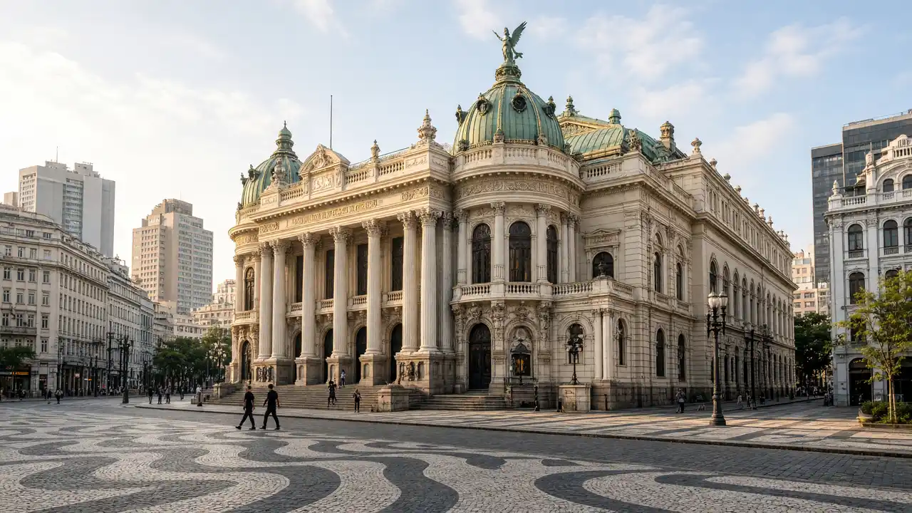
The Municipal Theatre, library and fine arts museum form a compact group for comparing façades. Praça XV then reveals another historic layer around Paço Imperial. Choose one exhibition or stay with exterior viewing rather than attempting every institution in succession
Towards Praça Mauá
Around CCBB and Candelária, monumental buildings sit beside broad transport corridors. São Bento adds a climb. At the end, the Museum of Tomorrow’s elongated white structure and MAR’s wave-shaped roof show different approaches to the port district’s renewal
Stops in route order
Theatro Municipal — Theatre with columns, gilding and domes beside Cinelândia. View the façade from the square; book any interior tour separately
National Library of Brazil — Monumental library on Avenida Rio Branco. Separate the façade stop from reading-room access
Museu Nacional de Belas Artes — Art museum in a substantial historic building downtown. Check collection access before visiting
Paço Imperial — Colonial palace beside Praça XV, now a cultural centre. View the palace from the square before any exhibition visit
CCBB Rio de Janeiro — Cultural centre in a former Rio bank building. Check admission arrangements for the specific exhibition
Candelária Church — Church with twin towers and a large dome amid broad roads. Use controlled crossings on the approach
São Bento Monastery — Benedictine monastery on a hill beside the port district. Allow separate time for the ascent and church visit
Museum of Tomorrow — White museum with long projecting structures beside the water. View the building from Praça Mauá without making museum entry compulsory
Rio Art Museum — Two museum buildings beneath a shared wave-shaped roof. Compare the historic and modern buildings from the square
Access and planning
Walk through the centre in daylight and use active streets. Cross broad roads at designated crossings rather than following a straight line towards a visible building. Check museum closures and monastery access before setting out
Choose Cinelândia and Lapa for a shorter walk; explore port memory with the separate Valongo route
Map and stops
The numbered markers match the stops below. A marker does not guarantee an open entrance
Access: Approach or exterior view; admission to the interior is not confirmed
Theatro Municipal
Theatre with columns, gilding and domes beside Cinelândia
View the façade from the square; book any interior tour separately
Show on the city map ↗National Library of Brazil
Monumental library on Avenida Rio Branco
Separate the façade stop from reading-room access
Show on the city map ↗Museu Nacional de Belas Artes
Art museum in a substantial historic building downtown
Check collection access before visiting
Show on the city map ↗Paço Imperial
Colonial palace beside Praça XV, now a cultural centre
View the palace from the square before any exhibition visit
Show on the city map ↗CCBB Rio de Janeiro
Cultural centre in a former Rio bank building
Check admission arrangements for the specific exhibition
Show on the city map ↗Candelária Church
Church with twin towers and a large dome amid broad roads
Use controlled crossings on the approach
Show on the city map ↗São Bento Monastery
Benedictine monastery on a hill beside the port district
Allow separate time for the ascent and church visit
Show on the city map ↗Museum of Tomorrow
White museum with long projecting structures beside the water
View the building from Praça Mauá without making museum entry compulsory
Show on the city map ↗Rio Art Museum
Two museum buildings beneath a shared wave-shaped roof
Compare the historic and modern buildings from the square
Show on the city map ↗
Before the walk
- City pavements, squares and a climb to the monastery
- Walking time excludes exhibitions, queues and long breaks
- Calculated using the OSM pedestrian network; not verified by an on-site walk
- View buildings from outside; closed courtyards and interior passages are not essential parts of the walk
Check hours, tickets and access with each venue. Barriers may change the track and queues may add time. Accessibility has not been surveyed on site
Questions before the walk
How long is this walk?
The mapped route is 3.7 km, with about 55 minutes of walking at an assumed 4.2 km/h. Breaks, visits and terrain can increase the total time
What should be checked before setting out?
Walk through the centre in daylight and use active streets. Cross broad roads at designated crossings rather than following a straight line towards a visible building. Check museum closures and monastery access before setting out
How can the walk be shortened or continued?
Choose Cinelândia and Lapa for a shorter walk; explore port memory with the separate Valongo route
Sources and verification
Written by walkymap from remotely checked sources. No on-site walk is claimed
en.wikipedia.org — Theatro Municipal (Rio de Janeiro) ·
en.wikipedia.org — National Library of Brazil ·
en.wikipedia.org — Museu Nacional de Belas Artes ·
en.wikipedia.org — Paço Imperial ·
en.wikipedia.org — Centro Cultural Banco do Brasil ·
en.wikipedia.org — Candelária Church ·
en.wikipedia.org — São Bento Monastery ·
en.wikipedia.org — Museum of Tomorrow ·
www.openstreetmap.org — www.openstreetmap.org ·
© OpenStreetMap contributors · ODbL. Track geometry and distance are from the route dataset
Elevation estimate: Mapterhorn. Terrain model; stairs and small changes in level may be missed